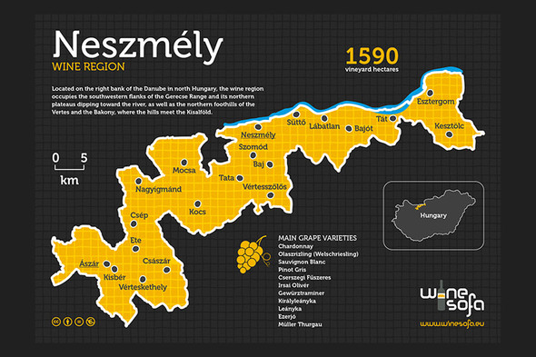
It is almost impossible to clearly delineate the Neszmély wine region geographically due to its segmentation. From the west to the east first we arrive to the Ászár district being the area of the Bársonyos hills. (However, many say that Bársonyos hill is not identical with Vértesalja. The former is separated from Vértesalja by the valley of Által-ér [brooklet] that takes its rise on the south of the settlement Császár and flows by Pusztavám to feed first Lake Bokodi then, a series of other lakes, namely Lake Környei, the reservoir of the power plant at Tatabánya, Lake Öreg in Tata, the Ferencmajor fish pond system next to Naszály just to reach the Danube between Almásfüzítő and Dunaalmás with two mouths.) The hills sloping towards the north are interspersed with erosion and derasion valleys and their highest point does not even reach 300 m. On the land of argillaceous and sandy lake deposit and of loess from the quaternary, the main soil forming rock of the vineyards is loess. On a major part of the area the soil is brown forest soil with clay infiltrated. The hills are bordered by Által-ér on the south, as already mentioned, Bakonyalja and Sokoró on the west and Gerecse on the east, while on the north it fits into the Igmánd-Kisbér basin. The wine region also expands to the area of the latter two. The argillaceous hills of the Igmánd-Kisbér basin are covered with loess and sandy deposit and this area is host to the settlements Nagyimánd, Csép and Kocs. This landscape is bordered on the north by the Győr-Tata terrace which, as the offset of Kisalföld, can be separated to a lower and a higher flood plain along the Danube and is mainly made of river deposit. (The settlement Mocsa is located on this area.) The core of the wine region can be found on the western and northern slopes of Gerecse. Similarly to Vérteskethely hidden within the Bársonyos hills, Vértesszőlős located on the Gerecse has nothing to do with the Vértes hills. The western side of the hills composed mainly of Dachstein limestone and dolomite are bordered by the peaks of Asszonyhegy (375 m) and Nagy-Somló (425 m) on the west, and on the south by Hosszúvontató, Nagy-Dobó-hegy, Agostyáni-hegy, Öreg-Kovács and Hajagos. The piedmonts are covered with loess up to an approximate height of 350 m and around the mouth of Által-ér and at Vértesszőlős, sinter can also be found. The hills are separated from the Vértes by the valley Tatai-árok and are bordered by the Zsámbék basin from the south and southeast, while its natural border on the north is the Danube. The area encircled by the settlements Dunaszentmiklós, Dunaalmás and Neszmély is the historical and, at the same time, current core of the wine region. Nagy-Somló, Korma-hegy (300m) and Meleges (274m) located in the outskirts of Neszmély are also the areas accommodating the most widely-known parcels of vineyards. The areas sloping towards the north are warmed by the sunrays reflected by the Danube and the north winds reduce the risk of fungi diseases. The argillaceous soil is rich in trace elements and minerals. On the northeast side of Gerecse, towards Süttő, Lábatlan, Nyergesújfalu and Bajót, vineyards were planted on sand ridges, and on the northern parts of limestone hills (facing the Danube) and a bit further off from the Danube on the southern piedmonts. A good example of this latter is Kő-alja dűlő (parcel of vineyard) laying on the southern slopes of Öreg-kő (374 m) to the east of Bajót. The vineyards of Tát lay on alluvial soil on the east from here, while the vineyards of Esztergom and Kesztölc are established on the limestone and dolomite blocks of the Pilis hills. It is true for the whole of the wine region that the climate conditions are moderate, the number of sunshine hours per year is around 2000, while the yearly precipitation is 550-650 mm.
Download normal or printer friendly version of poster (A3).
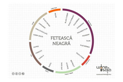
For anyone who would like a little more insight into Neszmély wine region, click here.